Insert EXIF Metadata and
GPS Location into Photos
Add a visible stamp/watermark
to your photos in a batch.
Arclab Watermark Studio allows you to add a visible text watermark with EXIF Metadata, like e.g. Aperture, Exposure Time, ISO Speed, GPS, etc. to your photos. You can combine multiple metadata values to a text watermark. The position of the watermark, text font, text color and text size can be freely defined.
Sample: Date/Time and GPS Location
Text Watermark:
{DateTaken}
{GPSDeg}
There are multiple placeholders in different formats for date, time and location available, e.g. to use the U.S. date format MM/DD/YYYY:
{DateTakenMonth}/{DateTakenDay}/{DateTakenYear}

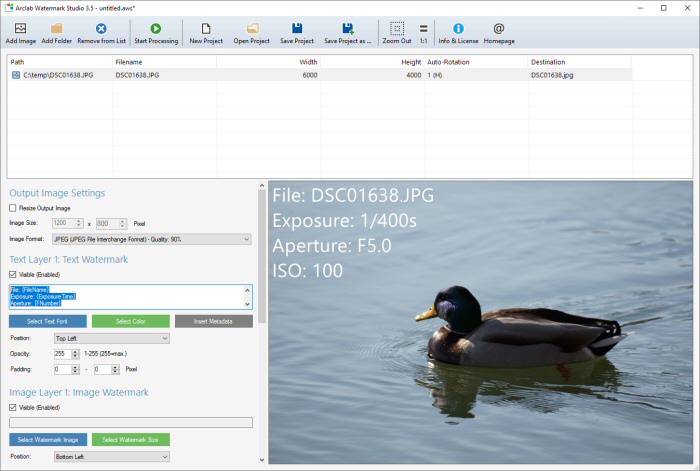
Sample: File Name, Exposure Time,
Aperture F-Number and ISO
Text Watermark:
File: {FileName}
Exposure: {ExposureTime}
Aperture: {FNumber}
ISO: {ISOSpeed}
Click on "Insert Metadata" to show a list of all available metadata placeholders and the corresponding meta values for the currently selected image. You can combine the placeholder(s) with custom text.
EXIF Metadata Values:
Please note that - depending on your camera - some EXIF metadata values might not be available!
| EXIF Metadata: | Placeholder: | Description: |
| File Title | {FileTitle} | Filename without extension, e.g. DSC01638 |
| File Name | {FileName} | Filename with externsion, e.g. DSC01638.jpg |
| File Path | {FilePath} | Full path, e.g. C:\temp\DSC01638.jpg |
| Author | {Author} | Author of the image |
| Copyright | {Copyright} | Copyright notice |
| Image Unique ID | {ImageUniqueID} | Unique-ID of the image created by the camera |
| Title | {Title} | Image title |
| Subject | {Subject} | Image subject |
| Comment | {Comment} | Image comments |
| Keywords | {Keywords} | Image keywords |
| Orientation | {Orientation} | Image orientation, e.g. Rotate 180 |
| Width | {ImageWidth} | Image width (after auto-rotation) |
| Height | {ImageHeight} | Image height (after auto-rotation) |
| Date Taken | {DateTaken} | EXIF Date and time the image was taken DD.MM.YYYY HH:MM:SS |
| {DateTakenDay} | Day in format: DD | |
| {DateTakenMonth} | Month in format: MM | |
| {DateTakenYear} | Year in format: YYYY | |
| {DateTakenHour} | Hour in format: HH | |
| {DateTakenMinute} | Minutes in format: MM | |
| {DateTakenSecond} | Seconds in format: SS | |
| Camera Manufacturer | {CameraManufacturer} | Manufacturer of the camera used to take the photo |
| Camera Model | {CameraModel} | Camera model used to take the photo |
| Lens Make | {LensMake} | Manufacturer of the lens used to take the photo |
| Lens Model | {LensModel} | Lens model used to take the photo |
| Exposure Time | {ExposureTime} | Exposure time as N/D in seconds, e.g. 1/50s |
| Exposure Time Decimal | {ExposureTimeDec} | Exposure time as decimal value, e.g. 0.02s |
| Exposure Program | {ExposureProgram} | Exposure program used to take the photo, e.g. Aperature priority |
| Aperture F-Number | {FNumber} | Aperture as F-number, e.g. F2.0 |
| ISO Speed | {ISOSpeed} | ISO Sensitivity, e.g. 400 |
| Focal Length | {FocalLength} | Focal length (in mm), e.g. 8mm |
| Focal Length 35mm | {FocalLength35mm} | Focal length in 35mm equivalent, e.g. 70mm |
| Flash | {Flash} | Shows if flash and red-eye reduction was used |
| GPS Degrees | {GPSDeg} | GPS coordinates in degrees (latitude and longitude) |
| GPS Decimal | {GPSDec} | GPS coordinates as decimal values (latitude and longitude) |
| GPS Latitude | {GPSLatitude} | GPS Latitude in degrees, minutes, seconds |
| GPS Latitude Decimal | {GPSLatitudeDec} | GPS Latitude as decimal value |
| GPS Latitude Reference | {GPSLatitudeRef} | GPS Latitude reference, e.g. N (North) |
| GPS Longitude | {GPSLongitude} | GPS Longitude in degrees, minutes, seconds |
| GPS Longitude Decimal | {GPSLongitudeDec} | GPS Longitude as decimal value |
| GPS Longitude Reference | {GPSLongitudeRef} | GPS Longitude reference, e.g. E (East) |
| GPS Altitude | {GPSAltitude} | GPS Altitude in meters , e.g. 405m |
| GPS Image Direction | {GPSImgDirection} | GPS Image direction in degrees |
| GPS Image Direction Reference | {GPSImgDirectionRef} | Direction reference: T = True North or M = Magnetic North |
Test Watermark Studio
Explore Arclab Watermark Studio with our test version for MS Windows.
The test version is fully operational and allows you to test all features
of the software.